Diamond Head Hike
화산 분화구
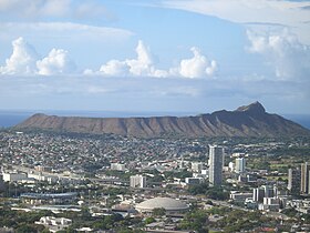
Diamond Head is the name of a volcanic tuff cone on the Hawaiian island of Oʻahu and known to Hawaiians as Lēʻahi, most likely from lae 'browridge, promontory' plus ʻahi 'tuna' because the shape of the ridgeline resembles the shape of a tuna's dorsal fin. Its English name was given by British sailors in the 19th century, who mistook calcite crystals on the adjacent beach for diamonds. <Wikipedia>
https://en.wikipedia.org/wiki/Diamond_Head,_Hawaii
Address: Honolulu, HI 96815
산책 겸 다녀온 Diamond Head Hike. 화산 분화구를 오르는데 엄청난 절경은 아니지만 호놀루루에 가면 누구나 가볍게 오르고 해돋이를 볼 수 있는 곳이라서 올랐습니다. 새벽 6시에 가로등 하나 없는 언덕을 전지도 없이 멋모르고 올랐는데 내려오면서 보니 아주 거친길을 걸었고 많은 계단을 뒷 사람들 땜에 숨도 안 쉬고 올랐지요(거짓말 좀 보태서요).^^ 산을 오르면 그 산 자체는 볼 수가 없으니 오르기 전 날에 밑에서 바라봤던 풍광과 큰섬에 갈 때 비행기에서 찍은 사진을 함께 올립니다. 어디를 가나 새로움과 신비로움을 동시에 느끼니 여행은 정신부터 건강해지겠다는 마음입니다. Enjoy!

비행기에서 본 Diamond Head Cone

동물원(Honolulu Zoo)에서 본 Diamond Head
https://en.wikipedia.org/wiki/Honolulu_Zoo

Camp McKinley
The United States became a world power and acquired overseas holdings as a result of the Spanish-American War. Hawai'i's strategic location made it critical to the military interests of the United States.

On August 12, 1898, the United States ratified the treaty of annexation. Four days later, the 1st New York Volunteer Infantry Regiment arrived by ship in Honolulu and established Camp McKinley, the first U.S. Army camp in Hawai'i. Camp McKinley was set up in Kapi'olani Park, at the base of Diamond Head, next to Waikiki.
In 1900 the Organic Act proclaimed Hawai'i as a territory of the United States.


Waikiki 해변에서 본 Diamond Head

January 26, 2017
새벽에 Diamond Head 중턱에서 바라본 북동쪽 산동네 'Wilhelmina Rise' 풍광.

Diamond Head Lighthouse

Diamond Head Lighthouse is a United States Coast Guard facility located on Diamond Head in Honolulu,

정상에 올라 해돋이를 보려는데 동쪽하늘에 구름이 듬성 듬성 떠있고 거센 바람이 붑니다.
이 무슨 고생인가?


아직도 등불이 보이나 호놀루루가 아침을 맞이하는 중입니다.

저 멀리 끝쪽에 호놀루루 국제공항이 있고 산이 보이는 곳이 진주만(Pearl Haber)이다.

분홍색 건물은 Royal Hawaiian Hotel
https://www.royal-hawaiian.com/

구름 위로 해가 보인다. 못 보는 걸로 알고 있다가 보이니 신납니다.


하얀 건물 옆에 안내소가 있는데 그곳이 둥그런 분화구의 가운데라고 봅니다.

평평한 안내소 근처까지 내려와서 해돋이를 봤던 정상을 다시 봅니다.

저쪽 나무 밑에서는 군인들이 훈련을 받는 중이군요.

여기가 Diamond Head 화산 분화구 가운데입니다.

화산 분화구의 한가운데 서있으니 분화구라는 실감이 덜 합니다.
다음에는 Waikiki beach와 주변에서 본 풍광을 보여드리겠습니다.
♪ Royal Hawaiian Hula - George de Fretes
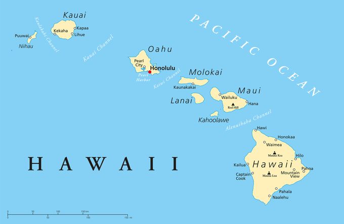
Main islands
The eight main islands of Hawaii (also called the Hawaiian Windward Islands) are listed here. All except Kahoʻolawe are inhabited.
| Island | Nickname | Area | Population (as of 2010) | Density | Highest point | Elevation | Age (Ma)[8] | Location |
|---|---|---|---|---|---|---|---|---|
| Hawaiʻi[9] | The Big Island | 4,028.0 sq mi (10,432.5 km2) | 185,079 | 45.948/sq mi (17.7407/km2) | Mauna Kea | 13,796 ft (4,205 m) | 0.4 | 19°34′N155°30′W |
| Maui[10] | The Valley Isle | 727.2 sq mi (1,883.4 km2) | 144,444 | 198.630/sq mi (76.692/km2) | Haleakalā | 10,023 ft (3,055 m) | 1.3–0.8 | 20°48′N156°20′W |
| Oʻahu[11] | The Gathering Place | 596.7 sq mi (1,545.4 km2) | 953,207 | 1,597.46/sq mi (616.78/km2) | Mount Kaʻala | 4,003 ft (1,220 m) | 3.7–2.6 | 21°28′N157°59′W |
| Kauaʻi[12] | The Garden Isle | 552.3 sq mi (1,430.5 km2) | 66,921 | 121.168/sq mi (46.783/km2) | Kawaikini | 5,243 ft (1,598 m) | 5.1 | 22°05′N159°30′W |
| Molokaʻi[13] | The Friendly Isle | 260.0 sq mi (673.4 km2) | 7,345 | 28.250/sq mi (10.9074/km2) | Kamakou | 4,961 ft (1,512 m) | 1.9–1.8 | 21°08′N157°02′W |
| Lānaʻi[14] | The Pineapple Isle | 140.5 sq mi (363.9 km2) | 3,135 | 22.313/sq mi (8.615/km2) | Lānaʻihale | 3,366 ft (1,026 m) | 1.3 | 20°50′N156°56′W |
| Niʻihau[15] | The Forbidden Isle | 69.5 sq mi (180.0 km2) | 170 | 2.45/sq mi (0.944/km2) | Mount Pānīʻau | 1,250 ft (381 m) | 4.9 | 21°54′N160°10′W |
| Kahoʻolawe[16] | The Target Isle | 44.6 sq mi (115.5 km2) | 0 | 0 | Puʻu Moaulanui | 1,483 ft (452 m) | 1.0 | 20°33′N156°36′W |

한국 제주도 - Population: 604,771 (Oct 2014), Area: 714 mi² (1,848 km2 ), Highest elevation: 1,950 m (6,400 ft)
'아침정원 > A Moment in Time' 카테고리의 다른 글
| 와이키키 산책 중에 U.S. Army Museum에도 들리고_ ♪ Me and You on the Beach/ Chamras Saewataporn (0) | 2017.02.10 |
|---|---|
| 진주만(Pearl Harbor) 폭격과 애리조나 전함 기념관 _ ♪ 진주만을 기억하라! (0) | 2017.02.07 |
| '꽃들이 비맞는 모습' _ 너의 목소리(봄비 소리)/ 오세영 _ Amazing Grace (0) | 2017.01.12 |
| 가마우지와 친구들 [오후 산책, 12/27/16 - PST] _ 베토벤의 Romance for Violin & Orchestra No.2 (0) | 2017.01.02 |
| 조촐한 2016년 Christmas (0) | 2016.12.26 |